|
Date: Fri, 17 Jun 2011 15:08
To: "Wayne Roberts" <wroberts@maai.net>
From: Holliday Dental <teeth@mindspring.com>
Subject: RE: Mary D. Holliday...Parcel 41....Project STP-3213-00
(003)...BRMLB-3213-00 (005)...P.I.# 351130
Cc: Roads@Macon-Bibb.com,"Ross, Gerald" <gross@dot.ga.gov>,
Jim Cole <jcole@dot.ga.gov>,"Jeff Franklin"
<jfranklin@dot.ga.gov>,
<vetheridge@maai.net>,"Jeff Joyner"
<jjoyner@maai.net>,
"Hugh Wellman" <hwellman@maai.net>,"Steve Daniel"
<sdaniel@maai.net>,
"Steve Luxenberg" <steve.luxenberg@dot.gov>,
<Christy.Poon-Atkins@dot.gov>,<Chetna.Dixon@dot.gov>,
"John Christopher Clark" <Chris@clarksmithlaw.com>,
"Ford, Clinton" <cford@dot.ga.gov>,"Buchan, Ben"
<bbuchan@dot.ga.gov>,
"Grace Sparrow" <sparrowg@bellsouth.net>,
"Bibb County Commissioners" <erichardson@co.bibb.ga.us>,
<shart@co.bibb.ga.us>,<joeallen@co.bibb.ga.us>,<BIBBCOMMISH@aol.com>,
<bbivins@co.bibb.ga.us>,<ledwards@co.bibb.ga.us>,
"Mayor Robert Reichert" <r.reichert@macon.ga.us>,
"Miriam Paris" <miriam.paris@macon.ga.us>,
"lonnie miley" <lonnie.miley@macon.ga.us>,
"Metric Surveys"
<metricaerial@gmail.com>,<awomack@macon.com>,
crichardson@macon.com,Lee Martin
<mermaidlover@bellsouth.net>,
Susan Martin <shanberry@stratford.org>,
"Daniel P. Fischer" <FISCHER_DP@mercer.edu>,
"tomscholl@cox.net" <tomscholl@cox.net>,Alice Boyd
<dmbx1@cox.net>,
Carol Lystlund <clyst@att.net>,"JOM III GALLERY"
<john@jomiii.com>,,
Victor Jones <victor_jones_2000@hotmail.com>,
"Representative Allen Peake" <rmsceo@aol.com>,,
Rick Chellman
<chellman@tndengineering.com>,<teeth@mindspring.com>,
Richard Creswell <RWCreswell@aol.com>,,Jaime Kaplan
<jaimecay@aol.com>,,
nancy.white@macon.ga.us,,
"Lauren L. Benedict" <llbenedict@bostonlawmacon.com>,,
"Paul E. Fisher" <admin@pefisher.us>,
Mr. Roberts,
I do not want to rush you, but ...
(We) have not seen any response from my email sent to you on May 23rd.
Please indicate when we might see your response to the numerous
questions and issues below. As before, please reply-copy to all
the parties of this discussion. .
This email is being entered as a Public Comment to the MATS-TIP:
http://www.macon-bibb.com/MATS/TIP-2011.htm
to show how reluctant you and Moreland-Altobelli and GDOT seem to be to
disclose information about this Forest Hill Road project. You
appear to be hiding a lot of information away from public scrutiny on
this massive public project costing us Taxpayers over $30 Million
according to recent estimates.
Thank-you,
- Lindsay D Holliday
agent for Mary D Holliday
Date: Mon, 23 May 2011 06:51:20 -0400
To: "Wayne Roberts" <wroberts@maai.net>
From: Holliday Dental <teeth@mindspring.com>
Subject: RE: Mary D. Holliday...Parcel 41....Project
STP-3213-00 (003)...BRMLB-3213-00 (005)...P.I.# 351130
Cc: "Jeff Franklin" <jfranklin@dot.ga.gov>,
<vetheridge@maai.net>, "Jeff Joyner"
<jjoyner@maai.net>, "Hugh Wellman"
<hwellman@maai.net>, "Steve Daniel"
<sdaniel@maai.net>, "Steve Luxenberg"
<steve.luxenberg@dot.gov>,
<Christy.Poon-Atkins@dot.gov>,
<Chetna.Dixon@dot.gov>, "John Christopher
Clark" <Chris@clarksmithlaw.com>, "Ford,
Clinton" <cford@dot.ga.gov>, "Buchan, Ben"
<bbuchan@dot.ga.gov>, "Grace Sparrow"
<sparrowg@bellsouth.net>, "Bibb County
Commissioners" <erichardson@co.bibb.ga.us>,
<shart@co.bibb.ga.us>,
<joeallen@co.bibb.ga.us>,
<BIBBCOMMISH@aol.com>,
<bbivins@co.bibb.ga.us>,
<ledwards@co.bibb.ga.us>, "Mayor Robert
Reichert" <r.reichert@macon.ga.us>, "Miriam
Paris" <miriam.paris@macon.ga.us>, "lonnie
miley" <lonnie.miley@macon.ga.us>, "Metric
Surveys" <metricaerial@gmail.com>,
<awomack@macon.com>, crichardson@macon.com, Lee Martin
<mermaidlover@bellsouth.net>, Susan Martin
<shanberry@stratford.org>, "Daniel P. Fischer"
<FISCHER_DP@mercer.edu>, "tomscholl@cox.net"
<tomscholl@cox.net>,Alice Boyd <dmbx1@cox.net>, Carol
Lystlund <clyst@att.net>, "JOM III GALLERY"
<john@jomiii.com>, Victor Jones
<victor_jones_2000@hotmail.com>
Mr. Roberts,
We are surprised and shocked enough to be quite distracted after
reading your claim that "...the markers placed in Jan & Feb of this
year were approximate locations ...". This was never told to
us. You and Mr Wellman led us to believe the first set of stakes
were the factual points. I cannot image why I might waste
my time looking at " approximate locations " at a ROW
condemnation discussion. Your claim is patently absurd.
It was not until we challenged the first KC stake positions (through
our own diligence) that then a second set of stake locations was placed
nearby the first set.
Please send us documentation to back up your claim about "...the
markers placed in Jan & Feb of this year were approximate locations
..." Otherwise, please publicly retract your statements as
being incorrect, null and void.
Please explain why you have not emailed the (repeatedly) requested
information to us. I have already explained that we will
not (waste the time to) meet with you on site until we have this
information emailed (To All) with adequate time to review its
import. If the data sets are too large to email, then you
may post them on your website or on the GDOT website within public
view.
Also, please name the "designer liaison" to whom you refer-____.
After the reasonable requests above are all answered, we can move
forward with the ROW acquisition discursion.
Thank-you,
- Lindsay D Holliday
agent for Mary D Holliday
From: "Wayne Roberts" <wroberts@maai.net>
Date: Thu, 12 May 2011 10:10
Dr. Holliday,
I have received from the designer liaison the information you have
requested in your previous emails (on May 3rd and May 11th). I suggest
that we meet at your mother’s property to review the stakes that were
placed on March 17, 2011 and so I can deliver to you a CD with the
requested data. Perhaps you would like to have a third party present to
review the stakes with us and how each stake corresponds to the right
of way and construction plans.
Regarding your question about a type of guarantee and warranty to
ensure the orange barrier fence is not transgressed during the
construction of the roadway; the EPD/EPA is charged with ensuring all
Environmentally Sensitive Areas (ESA) remain undisturbed by the
contractor and its construction activities. The designer has delineated
this area on your mother’s property & marked it as an ESA with a
note referring the contractor to the General Notes sheets for
construction restrictions noted in the Environmental Resource Impact
Table. Although, no warranty will be given by GDOT on the right of way
option agreement, I have a copy of these regulations from the GDOT
Environmental Procedures Manual that I will give to you.
The stakes placed on your mother’s property on 3-17-11 were placed by a
survey crew and are the exact locations of the right of way and
easement points. As we discussed during our previous negotiation
meetings, the markers placed in Jan & Feb of this year were
approximate locations determined by the designer liaison & r/w
staff since many the stakes from the original staking were no longer
present.
The construction let date for this project is quickly approaching &
we must conclude negotiations soon, please contact me with some dates
that are convenient for you to review the stakes, right of way plans
and the requested information.
Thanks,
Wayne Roberts
From: Holliday Dental [ mailto:teeth@mindspring.com]
Sent: Wednesday, May 11, 2011 6:06 AM
To: Wayne Roberts
Cc: Jeff Franklin; vetheridge@maai.net; Jeff Joyner; Hugh Wellman;
Steve Daniel; Steve Luxenberg; Christy.Poon-Atkins@dot.gov;
Chetna.Dixon@dot.gov; John Christopher Clark; Ford, Clinton; Buchan,
Ben; Grace Sparrow; Bibb County Commissioners; shart@co.bibb.ga.us;
joeallen@co.bibb.ga.us; BIBBCOMMISH@aol.com; bbivins@co.bibb.ga.us;
ledwards@co.bibb.ga.us; Mayor Robert Reichert; Miriam Paris; lonnie
miley; Metric Surveys; teeth@mindspring.com; awomack@macon.com
Subject: RE: Mary D. Holliday...Parcel 41....Project STP-3213-00
(003)...BRMLB-3213-00 (005)...P.I.# 351130
Mr Roberts,
I have received your email (5-4-11) where you suggest meeting with us
before (and without first) emailing the ROW data we requested on May
3rd.
My family still needs some specific data before we can proceed with an
independent, 3rd party evaluation and survey. Evaluation of this
data must proceed any reasonable discussion of any ROW acquisition
settlement.
That is why we are now restating our request for the following data:
1- Coordinate values for each KC marker point, and
2- Auto CAD file for this ROW parcel, and
3- Comprehensive Tree Survey data for this parcel that was done by
Stantec a few years ago.
It might also help us if you could also provide:
4- an explanation as to why the KC markers were placed
differently by yourself and Mr Wellman?
5- What type of guarantee and warranty can we have that the orange
barrier fence will not be transgressed during construction?
6- Please email the requested data and explanations to [all parties to
this email] so that we can all be on the same page.
Thank-you,
- Lindsay D Holliday
agent for Mary D Holliday
At 10:45 AM 5/4/2011, Wayne Roberts wrote:

Dr. Holliday,
As you know, we have attempted for several weeks to schedule a meeting
at your mother's parcel to review the right of way and easement stakes
placed by the surveyors in March. During our past meetings, we have
discussed in detail other issues such as attempting to work around
several large trees located near the driveway & proposing GDOT use
dark concrete on the new driveway. At our next meeting, I will
certainly look at the large tree located within the stream buffer you
mentioned & also give you the proposed location of the orange
barrier fence. I will also bring the additional three items you
requested in your email.
As I remember, Friday and Monday afternoons work best for you. I am
available this Friday until 3pm and all day on Monday. I am also
available most any night during the week if you prefer to meet after
regular working hours.
I look forward to hearing from you.
Thanks,
Wayne Roberts
-----Original Message-----
Date: Tue, 03 May 2011 09:15:33 -0400
To: "Wayne Roberts" <wroberts@maai.net>
From: Holliday Dental <teeth@mindspring.com>
Subject: RE: Mary D. Holliday...Parcel 41....Project STP-3213-00
(003)...BRMLB-3213-00 (005)...P.I.# 351130
Cc: "Jeff Franklin"
<jfranklin@dot.ga.gov>,<vetheridge@maai.net>,
"Jeff Joyner" <jjoyner@maai.net>,"Hugh Wellman"
<hwellman@maai.net>,
"Steve Daniel" <sdaniel@maai.net>,
"Steve Luxenberg"
<steve.luxenberg@dot.gov>,Christy.Poon-Atkins@dot.gov,
Chetna.Dixon@dot.gov,"John Christopher Clark"
<Chris@clarksmithlaw.com>,
"Ford, Clinton" <cford@dot.ga.gov>,"Buchan, Ben"
<bbuchan@dot.ga.gov>,
"Grace Sparrow" <sparrowg@bellsouth.net>,
Holliday Dental <teeth@mindspring.com>,
Bibb County Commissioners <erichardson@co.bibb.ga.us>,
<shart@co.bibb.ga.us>,<joeallen@co.bibb.ga.us>,<BIBBCOMMISH@aol.com>,
<bbivins@co.bibb.ga.us>,<ledwards@co.bibb.ga.us>,
Mayor Robert Reichert <r.reichert@macon.ga.us>,
Miriam Paris <miriam.paris@macon.ga.us>,
lonnie miley <lonnie.miley@macon.ga.us>,
Metric Surveys <metricaerial@gmail.com>
Dear Sirs,
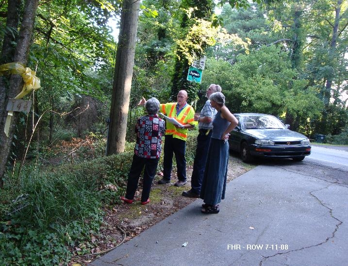
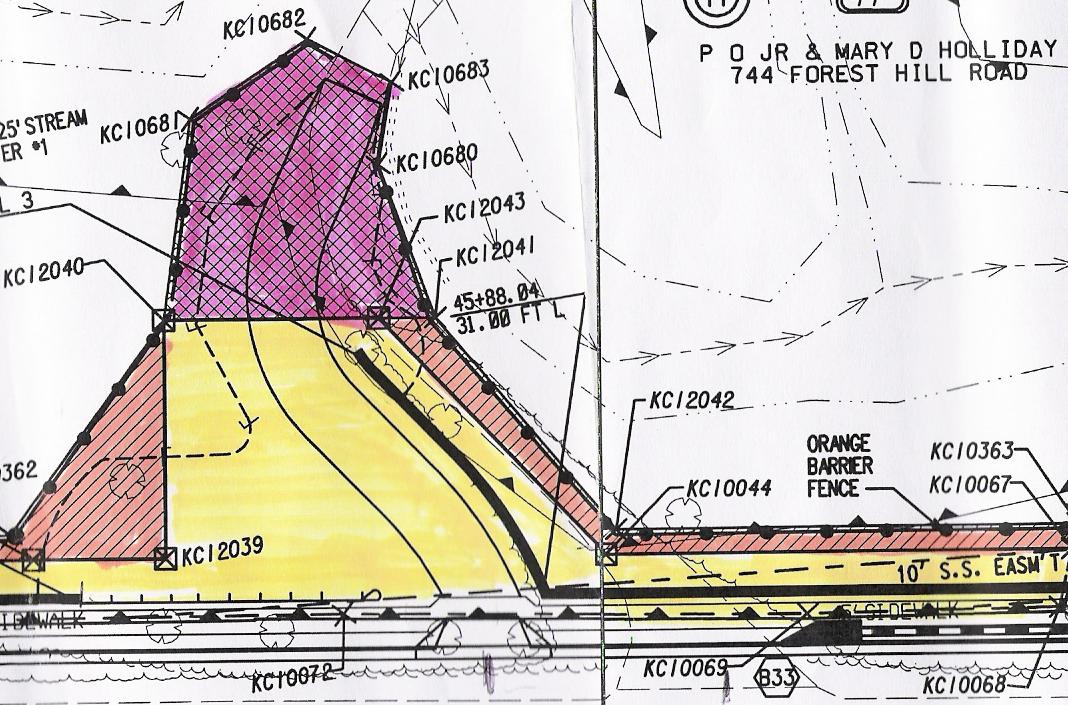
This web-posted photo displays some confusion about the ROW
boundaries:
http://www.macon-bibb.com/FHR/FHR-ROW-marked-20110326.JPG
Yellow tape on extreme right marks the stakes authorized by Mr
Roberts. The next yellow tape nearest it, marks the boundaries
according to stakes placed by Mr Wellman.
My family is confused because Moreland-Altobelli and their
subcontracting engineers, surveyors and ROW acquisition agents have
marked two competing sets of ROW, KC-point stakes.
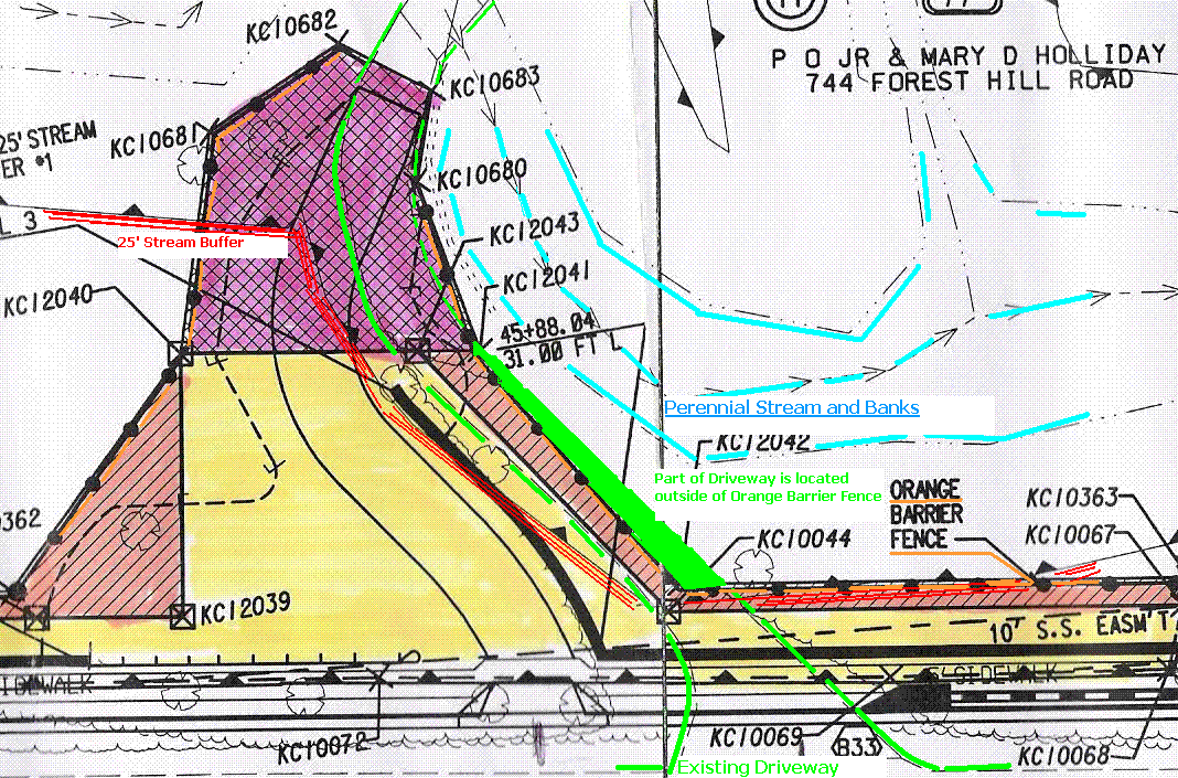
The fate of several hundred square feet of stream buffer and at least
one massive tree is in question. This tree lies within the 25
foot stream buffer and it is critical to maintaining the current course
of the stream and its banks. Large floods here have historically
(documented by the partially washed out brick wall) bypassed the bridge
and attempted to cut off the driveway.
How can we discern where the actual location of the proposed orange
"construction barrier fence" is?
Illustration of intrusion into the 25 foot stream buffer zone:
http://www.macon-bibb.com/FHR/ROW-744-Buffer-Stream4.GIF
Unless a better answer is provided, my family will need to
proceed with an independent, 3rd party evaluation and survey before we
can reasonably discuss any ROW acquisition settlement.
That is why we are now requesting the following data:
1- Coordinate values for each KC marker point, and
2- Auto CAD file for this ROW parcel, and
3- Comprehensive Tree Survey data for this parcel that was done by
Stantec a few years ago.
Thank-you,
- Lindsay Holliday
At 03:32 PM 3/24/2011, Wayne Roberts wrote:
Dr. Holliday,
Please contact me as soon as possible so we can schedule a time to
review the right of way stakes at your mother's
4- photos of responsible
surveyors and principals [garantors] beside each stake.
Would they stake their reputation on the location of these KC
markers?
Because GDOT and its subcontractors are responsible for this confusion,
it is reasonable to expect that [they] will be ultimately responsible
for any reasonable survey fees and consultations that will be incurred
to correct the confusion.
Date: Fri, 04 Mar 2011 10:12:52 -0500
To: "Hugh Wellman" <hwellman@mail.maai.net>,
Wayne Roberts <wroberts@maai.net>,Ken Sheets
<ksheets@co.bibb.ga.us>,
From: Holliday Dental <teeth@mindspring.com>
Subject: Re: Mary D. Holliday...Parcel 41....Project
STP-3213-00
(003)...BRMLB-3213-00 (005)...P.I.# 351130
Cc: Steve Luxenberg
<steve.luxenberg@dot.gov>,<Christy.Poon-Atkins@dot.gov>,
<Chetna.Dixon@dot.gov>,John Christopher Clark
<Chris@clarksmithlaw.com>,
"Ford, Clinton" <cford@dot.ga.gov>,"Buchan, Ben"
<bbuchan@dot.ga.gov>,
Grace Sparrow <sparrowg@bellsouth.net>
Mr Wellman,
A Few Critical Points:
- You have failed to "confirm" my very simple request to you in the
email below (Feb 25, 2011). It has now been 5 working days.
What is your reason for the delay? Do you need more time?
- My Mother and I are not finished with our right to negotiate
with you for "special stipulations". Any assumption to the
contrary was made on your part only. Do not attempt to force your
assumptions and words into our mouths. You have misrepresented
our status and our intentions. Therefore, I am asking you to:
Please respond with a confirmation that our negotiations are
ongoing, and that my side has not given up on reaching an
agreement.
- You have failed to place all the survey stakes that would delineate
the property you wish to purchase. This is highly irregular. This
does not meet the legal standard of real estate practice in
Georgia. It is unreasonable to enter into a real estate deal
without the property being clearly surveyed and marked. Any
demands for us to do so are clearly substandard, improper and
abusive. Are not licensed (Georgia) real estate agents supposed
to clearly mark the boundaries of the property they negotiate?
- There appears to be some genuine confusion over the partial staking
of the survey points, so I am suggesting that we stake ALL the
perimeter points of the property you wish to purchase. Do you
agree this would be the standard, usual, customary and reasonable path
to pursue our negotiations?
- I have asked you (email below 1-30-2011) to NOT contact my Mother
until we (you and I) have arrived at an agreement. I told you
that she was extremely distressed by this project, and that she did NOT
want to be involved in the details of our negotiations. You were
to negotiate with me as her agent. However, you have since then
sent her not one, but two, Registered Letters containing Unreasonable
Ultimatums. This effort on your part is clearly harassment of my
Mother, and you are now warned that we are deeply and extremely
concerned about this behavior. Any further harassment will not be
tolerated.
Is this clear to you?
Have you explained this clearly to Mr Wayne Roberts, and to Mr Ken
Sheets - both of whose names appear as signatories on the two
registered letters in question?
I need to receive a "Reply To All" email from you within 3 business
days - either answering all our concerns above, or explaining why you
need more time to answer all of our listed concerns.
Sincerely,
- Lindsay Holliday
agent for Mary D Holliday
Date: Fri, 25 Feb 2011 05:43:34 -0500
To: "Hugh Wellman" <hwellman@mail.maai.net>
From: Holliday Dental <teeth@mindspring.com>
Subject: Re: Mary D. Holliday...Parcel 41....Project
STP-3213-00
(003)...BRMLB-3213-00 (005)...P.I.# 351130
Cc: "Holliday Dental"
<teeth@mindspring.com>,<wroberts@maai.net>,
<Christy.Poon-Atkins@dot.gov>,<Chetna.Dixon@dot.gov>
Mr Wellman,
I want for you to re confirm to me (with copy to FHWA) that after
finally marking the ROW, as of yesterday, Feb 24, 2011, you are now
giving my family 10 days to consider your offer "or else".
Thank-you,
- Lindsay Holliday
cc to FHWA
At 07:25 PM 2/24/2011,
Hugh Wellman wrote:
Dr. Holliday,
Per your request please be
advised the remaining KC points have been marked on your Mother's
parcel (41), the only one that was not marked was KC 12046, this survey
point is not identified on our drawings, I assume you meant KC 12043
which we also marked. Points KC10066, KC10362 and KC12039 had
previously been marked.
Unfortunately this matter
will move forward with a 10 day letter regarding negotiations on
Monday. Since we don't have an agreement in place regarding this Parcel
41 we can not move forward with special stipulations. Please contact
GDOT after receiving the 10 day letter notice.
Hugh Wellman
-----Original Message-----
From: "Holliday Dental" <teeth@mindspring.com>
Sent 2/14/2011 10:43:31 PM
To: "Hugh Wellman" <hwellman@mail.maai.net>
Cc: "Holliday Dental" <teeth@mindspring.com>
Subject: Re: Mary D. Holliday...Parcel 41....Project STP-3213-00
(003)...BRMLB-3213-00 (005)...P.I.# 351130
Ok,
Thank-you.
At 03:29 PM 2/14/2011,
Hugh Wellman wrote:
Dr. Holliday,
I will check on the status
of this matter, and get back with you.
Have a good day.
Thank you,
Hugh Wellman
-----Original Message-----
From: "Holliday Dental" <teeth@mindspring.com>
Sent 2/14/2011 6:23:46 AM
To: "Hugh Wellman" <hwellman@mail.maai.net>, "Wayne"
<wroberts@maai.net>
Subject: Re: Mary D. Holliday...Parcel 41....Project STP-3213-00
(003)...BRMLB-3213-00 (005)...P.I.# 351130
Dear Sirs:
As of my inspection of the property yesterday, there were still no KC
markers near the requested locations. I did notice KC-12039, but
it was probably not a new placement, and I did not comment on it
previously, because it (KC-12039) is not on the perimeter of GDOT's
requested ROW that we are trying to establish and to visualize.
Please let us know when we might expect to see the requested KC
markers.
Thank-you.
Date: Sun, 30 Jan 2011 22:53
To: "Hugh Wellman" <hwellman@mail.maai.net>, Wayne
<wroberts@maai.net>
From: Holliday Dental <teeth@mindspring.com>
Subject: Re: Mary D. Holliday...Parcel 41....Project STP-3213-00
(003)...BRMLB-3213-00 (005)...P.I.# 351130
Mr Wellman and Mr Roberts,
Our family spent a few hours last weekend looking at the engineer's
drawings of the parcel and marking it off with yellow tape by linking
the KC survey points.
This weekend we spent a few more hours looking at it, and we realized
that we need more KC points identified because I just had to guess
where some of them were and we do not have an accurate representation
in some areas.
Thank you for marking KCI0682, 10681 and 12040.
We also need for engineers to mark KC10362, 10683, 12046, 12041, 12042,
10044. (there is a tree platted near this last marker that we can not
identify by location, and we question whether the creek may not be
accurately mapped near that point..?.. but things may become clearer
once these KC points are identified..?)
Mother will be the one to sign any final agreements, but she does not
want to be contacted directly with any queries because she is very
distressed about the entire affair. You may send her letters with
updates of our progress, if you desire, but do not challenge her to
answer you directly before she is ready to speak for herself.
Please send all questions directly to me. Copies may be
sent to her, but expect for me to answer.
Things might possibly slow down a bit now because I will be consulting
with legal advisors (by appointment) since my mother and I have never
been on the receiving end of a condemnation of property for a
politically contentious and broadly unpopular project before.
Thank you,
- Lindsay Holliday
At 02:11 PM 1/28/2011,
Hugh Wellman wrote:
Dr. Holliday,
Good afternoon, I was
checking on status in regard to your mother parcel and if she is ready
to move forward with this matter. You can contact me at anytime.
Please advise
Thank you,
Hugh Wellman
|
|
