Macon, Ga

Status in 2001
2001 Status
Return to
Forest Hill Road go to - CAUTION Macon 8-31-99 letter from Dr Tsai Eisenhower Parkway
Extension
|
Macon, Ga |
|
Status in 2001
|
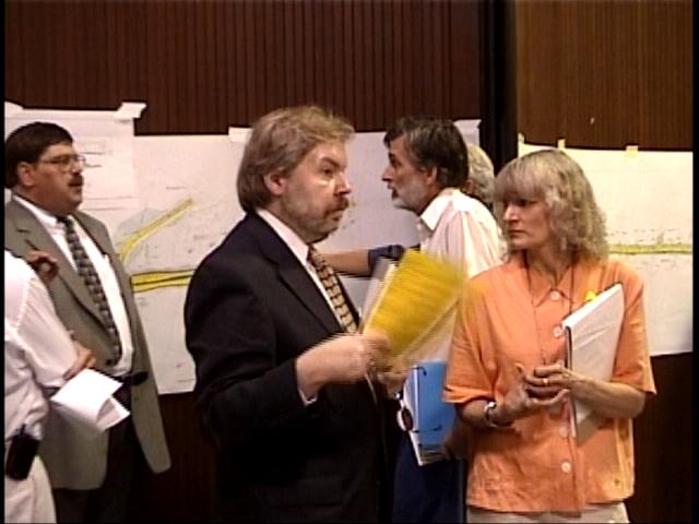
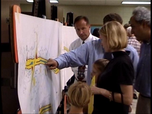
VIDEO
of 1st Public Meeting on June 11, 2001
| Ga DOT admits Forest
Hill Rd is relatively safer than Statewide average |
||
- - Forest Hill
Road - -
is "...20% Safer road than the Ga Staewide Average..." - Harvey Keepler, Ga DOT Environmental/Location Engineer (see letter here) October 26, 2001 |
||
|
Click on links below to see a misleading and deceptive letter (dated Oct 26, 2001) from GA DOT State Environmental and Location Engineer - Harvey Keepler |
| Keepler letter Page 1 - remember to hit the 'back' button after viewing the page. |
| Keepler - Page 2 - containing the False Data < < This page contains fictional and misleading information |
| Page 3 |
|
The above letter above was mailed to numerous people. The false data is exposed and rebutted below: a rebuttal by - F. Thomas Scholl, Jr. 4900 Oxford Road Macon, GA 31210
November __ 2001 Mr. Harvey D. Keepler DOT Office of Environment/Location 3993 Aviation Circle Atlanta, GA 30336-1593
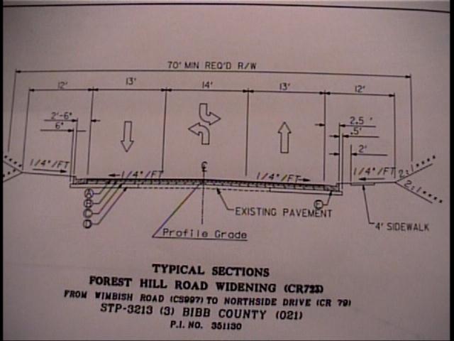
RE: STP-3213 (1) and STP-3213 (3)/BRMLB-3213 (5), Bibb county, P.I. Numbers- 350520 and 351130/352235, Proposed Improvements to Forest Hill Road
Dear Mr. Keepler: Thank you for your letter to me concerning the traffic volumes on Forest Hills Road. The traffic volume analysis you included is seriously flawed. I am glad you see the accident analysis was flawed as well. You recognize that the traffic accident data indicates that Forest Hill Road was 20% lower than the state average (here). This safety record is further enhanced by the fact that nearly 60% of the accidents occur at a handful of intersections at one end of the project. It is wasteful and incompetent to justify safety improvements for an entire road for problems in a single portion of the road, especially when the safety record is significantly better than the state average to begin with. The volume data appears to be a revision of the EA volume projections, however your conclusions remain unjustified. The error in the volume analysis is caused, first. by the grand conclusions drawn from limited and selective data plugged into the model. You base estimated volumes for six separate years, for as far into the future as 2025, on the data obtained from only three years in a span of eleven years where data was compiled for each of the eleven years. In fact I found data back to 1983. As you can see comparing 1994 to 1998 results in negative growth for the period on all three sites within the project area. These are the years the GDOT chose to compare in their publication of road volumes for 1998. Each year since 1996 the volume has dropped. (1999 GDOT volumes were estimates at these locations) Comparing years 1990 to 1998 one finds 0% annual growth on the first two sites and only a little bit of growth on the third. See Chart Below: |
| ID # | LOCATION | 1983 | 1984 | 1985 | 1986 | 1987 | 1988 | 1989 | 1990 | 1991 | 1992 | 1993 | 1994 | 1995 | 1996 | 1997 | 1998 | % change 1994-98 |
| 445 | FOREST HILL RD
N of Overlook Drive |
11,049 | 15,215 | 11,898 | 12,102 | 12,524 | 10,689 | 11,834 | 12,928 | 12,467 | 12,495 | 12,789 | 13,118 | 13,349 | 14,114 | 13,278 | 12,776 | (3) |
| 447 | S of Forest Hill Terrace | 4,772 | 5,217 | 5,580 | 5,687 | 6,360 | 6,264 | 6,339 | 7,588 | 6,711 | 7,483 | 7,523 | 7,820 | 8,387 | 8,531 | 7,918 | 7,679 | (2) |
| 449 | S of Newport Road | 6,194 | 6,590 | 6,519 | 7,854 | 7,316 | 7,835 | 5,552 | 8,705 | 6,244 | 9,372 | 9,912 | 10,164 | 10,357 | 11,008 | 10,089 | 9,690 | (5) |
|
The chart above is directly from a spreadsheet provided by the GDOT It required some diligence for Moreland Altobelli to find years to compare which could justify the plans for the road. Traffic volumes can be skewed by comparing pre-development periods with post development years since the same future growth cannot be expected. So making projections based on the past fifteen years is not appropriate. Even so, if we compare the most recent 15 years for which actual counts are available on all three locations within the project (1984 and 1998) one finds negative 1% annual growth on the section of road Moreland Altobelli predicts the greatest volumes (445 north of Overlook Drive)! Also it appears to me Moreland Altobelli includes projected volumes in their analysis of the road’s history, with their year 2000 figures; thus they project future volumes based on their projected inputted data!! In any case, the year 2000 volumes are wrong. The 2000 volumes seriously exaggerate the volumes provided by GDOT. On location 445 you have 14,500 cars per day while the GDOT shows 13,080 (your letter overstates this figure by 10.85 %.) On 447 they have 9,150 while GDOT has 8572 (your letter overstates this figure by 6.7 %.). On 449 you have 11,600 while GDOT has only10,760 (your letter overstates this figure by 7.8 %.). With such significant errors as soon as the year 2000, the exponential over-projection of volumes for the year 2025 will be huge. The 1985 volumes in your letter are wrong as well; they are all lower than the actual DOT numbers artificially creating growth that doesn’t exist. The GDOT year 2000 volumes for Forest Hill Road are lower than the 1996 volumes level, but roughly equivalent to 1995-96 volume levels. This is hardly evidence of a two percent growth through the year 2025! With GDOT’s year 2000 traffic volumes, the 1995 to 2000 annualized growth is either less than 1% or less than zero on all three sites. Looking back as far as 1990 the annualized growth still is still zero on the Overlook Road site (#445) where Moreland Altobelli projects the highest volumes. See table with Annualized Growth Rates below: |
||||||||||||||||
(1999 DOT volumes for these locations are estimates only and in each case were higher than the 2000 count. The #445 year 2000 count is an estimate as well, however it is 1,342 less than the 1999 estimate. )
The other two sites experience a low growth rates as well, from 0 to 2.36 % but one can see the growth rate is decreasing to less than 1% per year. By any accounting it is considerably less than the Moreland Altobelli projections you represent in your letter. The last five years of slight or no growth is stronger evidence of future growth than the volume comparisons with earlier years, unless strong supplementary evidence is offered. So far there has not been anything substantial offered in the EA or in any other document from Moreland Altobelli, the road program, or by your letter. If the annual growth rates from 1995 to 2000 hold true then location 447 will have a 2025 volume of 10,409 cars per day instead of 15,650 as you predict. Location 449 will have a 2025 volume of 13,066 instead of 21,300 as you predict. The no growth since 1990 on location 445 would indicate improvements should serve modest safety or other concerns rather than the 21,350 daily volume you predict for 2025. (The EA projected a volume of 28, 400 in this section of the road!!)
As any objective person can see, the complete history of the road reveals flat growth, especially over the last 5 years. The road is nearly fully developed and projections for growth need to be based on better data than comparing a few selected years of volumes. You offer commercial growth expectations to bolster the projections. The County engineer has made incredible claims, such as a Wal-Mart Super Store coming to the corner of Northside and Forest Hill Road–claims Wal-Mart knows nothing about. Road planners need to be more specific as to the commercial expectations and its impact on the road. These expectations of commercial development need to be within the bounds of what the Planning and Zoning Board could be expected to approve for this largely residential area.
Please be aware the Road Programs treatment of projected traffic volumes is a shady one. Planning and Zoning now projects 2025 volumes for Houston Road that are HALF the projections Moreland Altobelli and the Road Program used to justify the five lanes being built on that road today. While you do refer to other plans considered, as typical only the build or no-build options are presented for scrutiny by the public. Also typical, no one considers the advantages and benefits of the new signalization system the Road Program is completing. How will this new signalization improve the traffic flow on Forest Hills Road? Moreland Altobelli is silent here. Also they are silent about the county’s systematic plan and how the system might be utilized to improve traffic flow. The Road Program has never opened its systematic plan (if there is one) to public scrutiny. They offer no explanations about how an overloaded Vineville Avenue will carry the additional traffic the significantly widened Forest Hills Road will bring to Vineville. (Your own letter testifies to this increased traffic brought to Vineville.) The Road Program could well be creating a very expensive problem on Vineville, and may return to FHWY and GDOT for huge sums of monies to fix the problem they create today. I’m not certain why you argue against the criteria used for modeling by MATS for their study. However, rather than simply ignoring data you disagree with or do not like, I believe a better procedure would be to bring your dispute back to MATS and to convince them your criteria produces a more accurate modeling tool. After you do that, then work on GDOT’s traffic volume data. GDOT data alone shreds the projections and conclusions within your letter.
Finally, You do not address the serious errors of fact (traffic volumes) on which the EA bases its plans in the “need and purpose” statement. Instead you write to me justifications of the plan based on revised but still erroneous traffic volumes. It would seem the plan is more important than the justifications for the plan. With the erroneous accident date in the EA, which you admit, and the erroneous volume data, how can the project continue without a very serious revisiting of the plan? You do not address the cul-de-sac issues. You also do not address the serious public involvement issues I raised in my original letter of response to the EA. We are still waiting for the public meeting FHWY asked you to hold which we were told to expect in September. You should remember, had it not been for public input, you would never have known about the serious errors in the accident and volume data on which you were drawing your conclusions. Sincerely, F. Thomas Scholl, Jr. |
|
Macon residents protest planned expansion of Forest Hill Road By Gray Beverley The Macon Telegraph -Sunday 7-1-01 p1B with two Color Pics
A group of Macon residents Saturday was tying yellows ribbon 'round old oak trees. The loved ones in Saturday's activities were trees in the Forest Hill Road area, the target of a proposed road project that residents say is unnecessary and will destroy their neighborhood. The yellow ribbons marked trees that will most likely be removed to make room for the proposed expansion of Forest Hill Road. "They are talking about turning a residential road into an interstate," said Tom Scholl of CAUTION Macon, who was out Saturday morning with about a dozen others installing signs in protest. The Georgia Department of Transportation has proposed widening Forest Hill Road from a two-lane rural-type road to a four-lane divided urban-type road beginning at Vineville Avenue and ending at Wimbish Road.
The project, as described in a mandatory environmental assessment, also would widen Forest Hill beginning at Wimbish Road and ending 650 feet south of Northside Drive. Officials say the Forest Hill expansion is necessary to accommodate growth in north Macon as well as to address safety issues on what is recognized as a dangerous road.
Some residents gathered Saturday agreed that improvements could be made to Forest Hill, but they questioned the current proposal. Dan Fischer, an urban planner and CAUTION Macon participant, said the plan only looks at one road at a time, instead of considering the entire system. Fischer believes that if the Forest Hill plan goes forward as is, Vine-ville Avenue will suffer from congestion, and the stated goals of the expansion will not be achieved. "This (plan) offends logic," said Fischer. "If you can't accommodate traffic downstream, then you should not be generating it upstream," he said.
Other residents complained that the road widening --- if completed as planned the road would be some 100 feet wide --- would encourage traveling at higher speeds, thereby increasing the risk of danger. They insist that installing turn lanes, speed control devices and improving intersections could resolve the safety issues in the current road, while protecting the value of area homes.
Bibb County Commission Chairman Tommy Olmstead said that much of the debate is a matter of residents not wanting expansion in their back yards. Olmstead said the DOT plan considers future development and the proposed road projects are necessary. "We are going to do all we can to make it less intrusive to the neighborhood," he said. Fischer believes that a win-win proposal can be drafted. He and CAUTION Macon believe that voters in 1994 were not aware of what has been referred to as a "highway or no way" character of the Macon-Bibb County Road Improvement Program, which used a special sales tax to raise an estimated $131 million in local funding for road improvements throughout Bibb County. An estimated $150 million in state and federal funding also goes into the road program. Construction on the Forest Hill widening is scheduled to begin in 2006. Olmstead, who has met with the public on this issue, said he is willing to consult recognized engineering experts in an attempt to soften the impact to the community.
More information may be obtained from CAUTION Macon, which calls itself "a citizen's advocacy group promoting responsible road building in our neighborhoods," at its Web site, www.cautionmacon.org, or from the Macon-Bibb County Road Improvement Program at 755-0000. --- To contact Gray Beverley, call 744-4494 or e-mail gbeverley@macontel.com http://www.macontelegraph.com/content/macon/2001/07/01/local/FORESTHILL0701MT.htm |
| In the box below is the
Negative Response from a Moreland Altobelli employee - vs - my original request for public information: |
|
To: <teeth@mindspring.com>; Fri, 15 Jun 2001 15:06 From: Moreland Altobelli <MAMACON@BELLSOUTH.NET> CC: Angie Alexander <Angela.Alexander@dot.state.ga.us> Subject: Re: Fwd: Forest Hill residents want more access to maps
Mr. Holliday, I have discussed with The Department of Transportation's Office of Urban Design your request to borrow the public hearing displays from Monday's meeting and it is not the Department's policy to lend out copies of public hearing displays without an employee present to explain the displays. The Road Improvement Program is required to keep their copy of the displays in their office until after the comment period and I would be hesitant to lend our only copy out after that time. Both I and the Department would be happy to schedule a time to meet any individual who cannot visit our offices during regular hours. You may contact Angie Alexander of the Office of Urban Design at (404) 656-5444 or myself at 755-0000 if you have any questions. Joe Johnson
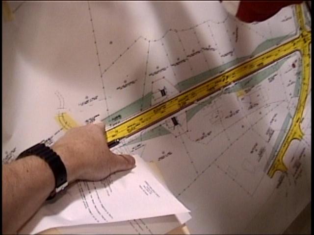
Date: Fri, 15 Jun 2001 11:33:46 -0400 To: "Palladi, Joe" <Joe.Palladi@dot.state.ga.us> Subject: Forest Hill residents want more access to maps Cc: Robert Reichert <rabr_awr@bellsouth.net>, rreicher@legis.state.ga.us, <Filomena.Mullis@macon.ga.us>, Tommy Olmstead <commish@mylink.net>, "Clay, Calder III" <cclayiii@aol.com>, "Tussing, Donald" <Donald.Tussing@macon.ga.us>, Vernon.RyleIII@macon.ga.us, James.thomas@macon.ga.us Dear Mr Palladi, A number of interested citizens would like to study the large maps [three duplicates of ] which were on display at the Springdale School meeting. Many are gainfully employed 40+ hours a week and are unable to take time off during work to visit the engineer's offices. Of those, some were out of town or previously committed during the evening meeting. So, as a partial remedy to this situation, I am offering to borrow one of the maps to make it available to citizens over the weekend. I am offering to place a reasonable deposit towards the safe return of the map. How much would it cost to print out or xerox a duplicate? My guess is between $25 -75. I have called the local office with this request. I have left a message for Joe Johnson at 478-755-0000. I am waiting for his response, but I felt it might help to send in a written request too. Thank-you, - Lindsay Holliday
PS - I also am concerned that the comment period - ending deadline of JUNE 21 - is inadequate. Some interested residents have not even seen the maps yet. Others are out of town on vacation and will not return until after JUNE 21.. _*_*_*_*_*_*_ *_*_*_*_*_*_*_ Lindsay Holliday (h) (478) 742-8699 3091 Ridge Ave. 31204 (o) 746-5695 360 Spring Street Macon, GA 31201 Homepage: http://www.hollidaydental.com |
|
|
|
The scope of the alternatives considered is clearly inadequate.
The Environmental Assessment for Forest Hill Road presented to the public on 6/11/01 is a fatally flawed document. If there are only two alternatives, then "NO BUILD" is preferable to the overbuilt alternative in the plan. There are many other alternatives that would meet the purpose and need as set out in the EA; however, DOT did not pursue any of them. Walter Kulash, an internationally acclaimed designer, drew a plan several years ago with the purpose and need and all of the physical data in mind. This plan was acceptable to the neighborhood. This design was not addressed as an alternative in the EA. If he did the design once, surely he or others could do it again. Solving the few intersection problems would solve all of the problems on the road.
Community Preferred Alternatives
The community would prefer to see Forest Hill Road remain two lanes, with the addition of turn lanes at the five intersections that need them. Left/Right/ and Thru lanes should be added at the intersection with Vineville Ave. The lane widths in the EA alternative are clearly over wide and should be narrowed to a maximum of 11 feet. This is completely consistent with the Purpose and Need Statement
Neither the TIP nor the 2025 Land Use and Transportation Plan was passed by the Citizen¹s Advisory Committee.
Because of over-built projects such as this one, incomplete information, and a failure to incorporate the values of the community, the CAC has not passed either the TIP or the 2025 Land Use plan for MATS. The fact that there is overwhelming citizen rejection of these plans has been ignored by officials. This is not how the process is intended to work. DOT should not run roughshod over communities and dictate how their neighborhoods should look. Federal Law intends that the desires of citizens are included in road plans, yet here we see a stellar example of a DOT that is out of control and out of touch. Objections to this project are a part of the record in every one of the public meetings held about the 2025 Land Use and Transportation Plan
The Road Improvement Program did not review the Project
This project is a part of the RIP, yet it was not reviewed in the Technical Advisory Committee. The TAC has reviewed other projects that have DOT involvement, and alternatives were presented prior to the issuance of a draft EA. This procedure was not followed on Forest Hill Road.
There was no "Project Design Team" on this project
The TAC of the RIP that includes a voting member from GaDOT, voted to employ a project design team on all controversial projects in the RIP. Forest Hill Road has always been a part of the RIP (and a contested part at that). This is clearly a project that should have this kind of interaction with the stakeholders in the community. In violation of this agreement, no project design team was empanelled for Forest Hill Road. No EA should be approved until this process has been completed. Any alternatives promulgated by this team should be added to a future draft EA and resubmitted for public comment.
The plan was misrepresented to the Citizen¹s Advisory Committee to the MATS.
At the CAC meeting prior to the public meeting, the only page given to members to consider was the 3-lane section of this project. Why wasn¹t the entire project on the agenda? The CAC is given certain responsibilities by the Federal Highway Administration, and they are unable to carry them out if the are given incomplete information. This is part of a pattern of problems that citizens see in this community with the MATS program.
The Plan does not accurately reflect population changes
The population in Bibb County has been stable with negligible growth for the last 10 years. Future projections do not see this changing. There will be no increase in traffic volumes due to population increases. The area is already built almost to capacity, and there is very little traffic that can come from new development. These measurable and observable facts are not considered in the EA.
The EA does not address all geographic data
There is a creek missing on the project plan. This is very significant as it represents a clear environmental threat, and a threat to the property owner. No plan should be approved unless it ACCURATETLY reflects all known physical and demographic information. Are there other creeks missing too? What else is missing? This omission casts doubt on the ability of the consultants to do an adequate job on an EA.
Segmentation
Although this project may not fall under the narrow LEGAL definition of segmentation, it is an example of segmentation nonetheless. This project is part of a larger plan known as the "Northwest Parkway". It should not be considered as a separate piece of the pie. The entire Northwest Parkway should be considered under one document with one purpose and need. Each segment is used to induce traffic to be considered as a problem in the next segment. This is an unethical way to do business. Improvements to I-75 and Riverside Drive should also be considered as mitigating projects in this plan.
Community Cohesion and Interaction
The placement of an over-wide road with rapidly moving traffic with split this long established neighborhood into two separate parts. Neighbors will not be able to cross the street to visit each other. The excessive noise levels will prohibit the enjoyment of any kind out outdoor activities. The churches along the road will suffer from these noise levels as well as the residences. Many of the residents of Forest Hill Road and the surrounding neighborhoods that will show an increase in traffic due to this project have lived in their houses for decades. This project will change the ways in which they are able to relate to each other. It will also serve to isolate the elderly residents who will be unable to use this kind of a mini-highway outside of their front door. There is simply no need to change the function of this road through a neighborhood. The induced changes to the land use will also be damaging not only to the residences on Forest Hill Road, but also to the adjoining properties.
Sound
The projected sound levels in the EA are in excess of federal limits. This is completely unacceptable. The noise levels for the residences just behind those lining the road were not given, but it is not unreasonable to assume that they will show a dramatic increase as well. There is no possible mitigation for this unacceptable sound level.
Dust, Odor, and Pollution
There will be a dramatic increase in all of these problems if the road is built as proposed. Macon expects to be designated as Non-attainment this summer. This project can only exacerbate this condition, particularly in the immediate project area. There will also be a greatly increased problem with non-point source pollution from the roadway, and its large impervious surface.
Aesthetics
At the present time, Forest Hill Road is a neighborhood road with a mature tree canopy the lines, and in some places over hangs the road. The over-wide swath this road will cut through the neighborhood will forever alter this beautiful scene. The road will also take a huge part of most front yards along the road making their dwellings much less attractive and saleable. Large retaining walls in front of several homes will be a serious detraction. There is no possible aesthetic value to the project. It can only do serious harm.
Incompatible with Community Goals
Our community has identified our neighborhoods as one of our most important assets. These values are clearly evident in public comments in all kinds of varied public meetings. This project is clearly in violation of our community goal to protect our neighborhoods. There is an alternative that would be compatible with these goals; it did not appear in this EA.
This project will induce incompatible land use changes
Widening this road will induce a change in the land use pattern from residential to commercial. This will be most evident along the 4-lane section. This change will be incompatible with current zoning. Every road of this type in Macon shows a shift from residential to commercial. Real estate agents and even our County Commission Chairman indicated that this shift would occur. It is in violation of our zoning plans, and it is in violation of the desires of the neighborhood.
The Project will decrease property values
The projected noise, decrease in aesthetics, and land use change to commercial will all have the effect of decreasing property values. The change in lot size, and proximity to the road will also serve to make the properties along Forest Hill Road less valuable. These same detractions will also spill over onto the adjacent residences and will serve to lower their property values as well. It will no longer be a safe place to live with children.
Transit
This road is not included in a comprehensive transit plan. In light of our non-attainment status this project should not be approved unless consideration is given to a transit plan. This is also of critical importance as our population ages. We must start to address this deficiency in our planning process now.
Emergency Response
The proposed cul-de-sacs will seriously impair the access of emergency vehicles to these streets.
Historic Properties will be impacted
There are several historic properties that will be seriously impacted by the proposed project. This statement is compatible with the findings of SHIPO. There are alternatives that would not damage these resources, but they were not presented as alternative in the EA.
|
|
June 12, 2001 article and Mr Palladi says he is quoted out of context - below: |
| "" THE QUOTE WAS TAKEN OUT OF
CONTEXT. WHILE I RESPECT THE VIEWS OF THE CITIZENRY, AND
SOME MADE VALID POINTS, THE ALL OR NOTHING OPINION
EXPRESSED BY SOME MAY PLACE THE RESIDENTS IN A WIN/LOSE
SITUATION VERSUS A WIN /WIN SITUATION. SOME FOLKS THAT I
SPOKE TO DIDN'T LIKE THE SCOPE OF THE PROPOSAL, BUT
OFFERED MORE CREATIVE SUGGESTIONS THAN " I DO NOT WANT".
THESE INCLUDED INTERSECTION IMPROVEMENTS WHICH WOULD
ADDRESS SOME OF THE ISSUES MOST RESIDENTS ACKNOWLEDGED.
"" - joe.palladi@dot.state.ga.us
-----Original Message----- From: Lindsay 'Doc' Holliday [mailto:teeth@mindspring.com] Sent: Tuesday, June 12, 2001 11:16 PM To: joe.palladi@dot.state.ga.us Cc: Christopher; Ron Woodgeard; Charles Richardson Subject: Forest Hill residents unhappy 1- If "No-Build" is one of only two options given to the citizens, then what is the matter with saying "down with the project"? See below comment by Joe Palladi. How else are the taxpayers to vote for "No-Build"? 2- DOT failed to draw in "CAUTION Creek" which runs beside Forest Hill on my family's property at 744. This is the same creek which washed out the roadbed in the early 1980s. Remember?? It took weeks to fix. Any "Environmental Assessment" that ignores CAUTION Creek is a Total FAILURE. Some of the "slope-work easement" is actually drawn in where the creek currently runs! One DOT employee tried to prevent me from indicating where this creek is on the inadequate DOT maps. I have this on video. And witnesses too... Wow... - Lindsay Holliday
Forest Hill residents unhappy with road plans 6-12-01 p 1B By Christopher Schwarzen The Macon Telegraph
No matter what the state does with Forest Hill Road, residents probably won't like it. What they want is the way things are for the most part, maybe straighten out a curve and add a turn lane or two. So said about 100 people Monday night at a Department of Transportation public hearing about the future widening of Forest Hill. But transportation officials say widening is inevitable. Current traffic counts are pushing the now two-lane road's capacity of 16,200. Four-laning between Vineville and Wimbish is a must to handle projected traffic figures of 28,000 daily trips along the road. To accommodate, DOT is planning to four-lane Forest Hill from Vineville Avenue to Wimbish Road. The rest of the project - from Wimbish to Northside - has been scaled back from four lanes to three. The change is the result of previous citizen and local official comments, but residents should not expect much more than that. Again, traffic figures, linked with accident rates, are climbing on Forest Hill, state transportation engineer Joe Palladi said.
"It's very difficult for people to understand this in terms of the future and how we're addressing those needs," Palladi said. If the road must be four-laned between Vineville and Wimbish, then most residents appear to want their streets to be cul-de-sacs, eliminating cut-through traffic, said County Commissioner Calder Clay, a resident of Overlook Avenue off Forest Hill. "My concerns are the same as everybody else," he said. "We're mainly concerned for the safety of the children in the area." DOT has offered to transform Overlook, The Prado and Drury Drive at Forest Hill into cul-de-sacs. "I hope they are," said Tres Herin of Riverdale Drive, who said he, too, is concerned about speeding traffic. But even the cul-de-sacs aren't a winner with everyone. Joe Patterson, who has lived on The Prado for 36 years, is concerned it will take longer for emergency vehicles to reach older residents living in the area.
"Won't the cul-de-sac make them have to go around the neighborhood and in off Ridge Avenue?" he asked. Patterson also doesn't believe anyone will take care of the grass, bushes and flowers planted on the grass strip of the cul-de-sac. "The city doesn't take care of them, and I don't believe residents will," he said.
Palladi said the state will look at individual comments but just saying "down with the project" won't work. [If "No-Build" is one of only two options given to the citizens, then what is the matter with saying "down with the project"? Do not that mean "No-build"? - Lindsay H]
"We want to know what people want instead as long as it handles volume adequately," he said. Unfortunately, with outer areas of Bibb County building out, more stress is being put on roads like Vineville and Forest Hill. Vineville is also on the books to be improved, but a plan has not been created yet. If the state goes through with the Forest Hill project as designed, work will not begin until 2006, unless funds are available earlier, Palladi said. The entire road will cost about $5.6 million. COMMENTS Written comments will be collected until June 21. To send one, mail it to Harvey Keepler, state environment and location engineer, Georgia Department of Transportation, 3993 Aviation Circle, Atlanta, GA 30336-1593.
- To contact Christopher Schwarzen, call 744-4213 or e-mail cschwarzen@macontel.com http://www.macontelegraph.com/content/macon/2001/06/12/local/roadwork.htm |
go to - CAUTION
Macon and see Eisenhower Parkway
Extension
| |
|
Macon, Ga |
This page maintained by Lindsay Holliday